


Area of Implementation
Nadia District
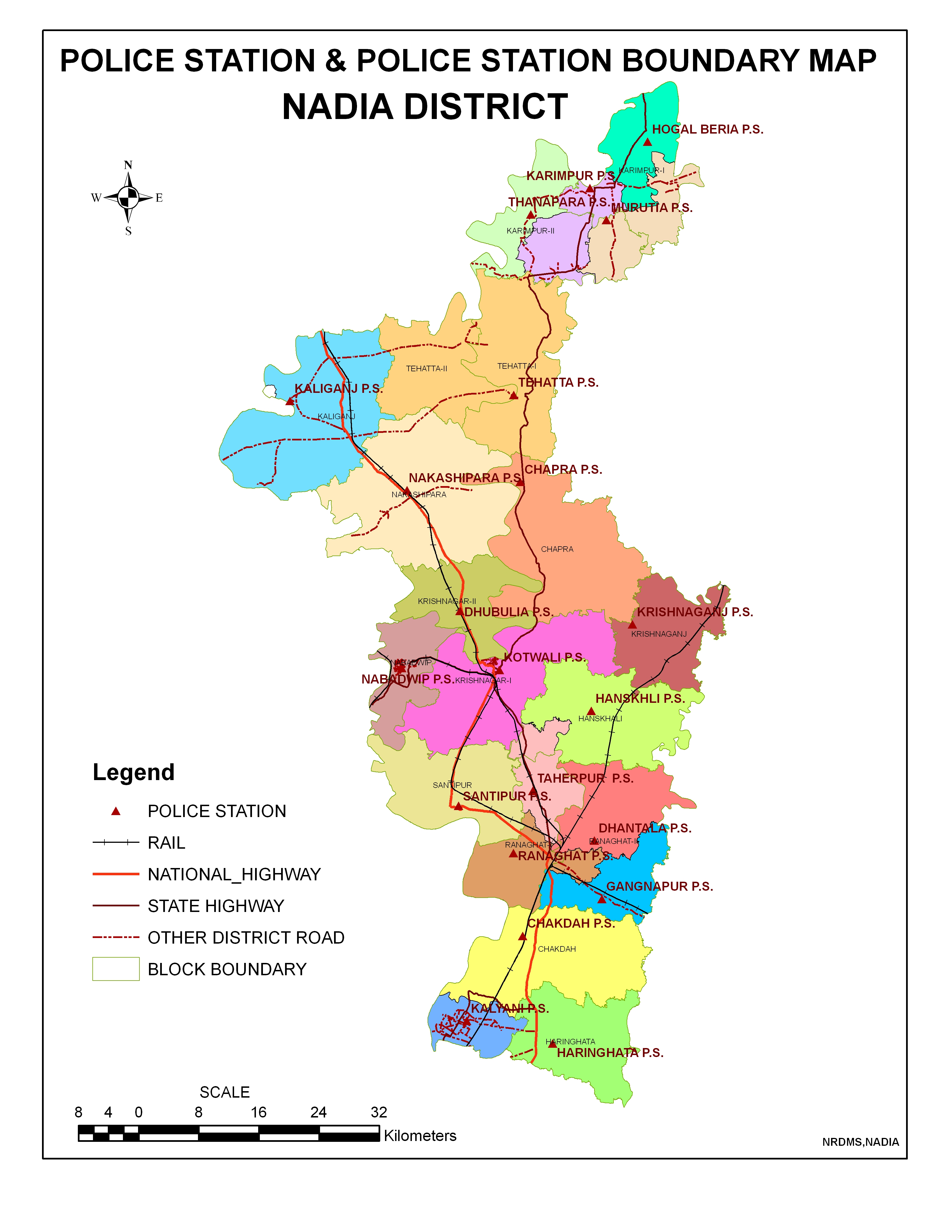
Click to enlarge.
The district of Nadia is situated in the heart of the Bengal delta held within the arms of the Ganga, namely, the Bhagirathi on the West and Mathabhanga on the North. The entire district lies in the alluvial plain of the Ganga and its tributaries. The alluvial plains are cut across by such distributaries as Jalangi, Churni and Ichhamati. Most districts in West Bengal take their name from the headquarters station of the district, but Nadia district takes its name not from Krishnagar, the headquarter but from Nadia or Nabadwip hallowed by the memory of Lord Shri Chaitanya Mahaprabhu who was born here on 18th February, 1486. The British district of Nadia was formed in 1787. The present district of Nadia after partition was formed by Notification No.545-GA dated 23rd February, 1948.
The district of Nadia is bounded on the north and north-west by the district of Murshidabad. On the south-east and east it is bounded by the Republic of Bangladesh. In the south and south-east the district is bounded by the district of North 24-Parganas.The shape of the district is irregular, lying North to South. The district is about 46ft. above the mean sea-level and the tropic of cancer divides the district into two parts.
For administrative convenience Nadia district is divided into four Subdivisions – Krishnagar Sadar, Ranaghat. Kalyani and Tehatta. The district has an area of 3927 sq kms having a population of 46,04,827 as per Census 2001. Out of that SC & ST population are 13,65,985 and 1,13891 respectively. The district has 17 Panchayet Samities consist of 187 Gram Panchyets and 8 Municipalities. Total number of Police Stations in the district is 19. The density of population in this district is 1173 persons per sq km. Nadia district has 950 females as against 1000 males. The majority of the people of the district speaks Bengali followed by Hindi, Santali and other. Religionwise about 73.75% are Hindus and 25.42% are Muslims. In the district of Nadia the percentage of literacy by sex is 72.30 (Male) & 59.60 (Female) as per Cencus 2001. The important rivers of the district are Bhagirathi, Churni, Mathabhanga, Ichamati and jalangi.
Krishnanagar Sadar subdivision consists of Krishnanagar municipality, Nabadwip municipality and seven community development blocks: Kaliganj, Nakashipara, Chapra, Krishnanagar–I, Krishnanagar–II, Nabadwip and Krishnaganj.
Kalyani subdivision consists of Chakdaha municipality, Gayespur municipality, Kalyani municipality and two community development blocks: Chakdaha and Haringhata.
Ranaghat subdivision consists of Shantipur municipality, Ranaghat municipality, Birnagar municipality and four community development blocks: Hanskhali, Shantipur, Ranaghat–I and Ranaghat–II.
Tehatta subdivision consists of four community development blocks: Karimpur–I, Karimpur–II, Tehatta–I and Tehatta–II.
Krishnanagar is the district headquarters. There are 19 police stations, 17 development blocks, 8 municipalities, 187 gram panchayats and 2639 villages in this district.
Parnership Model Block Ranaghat I
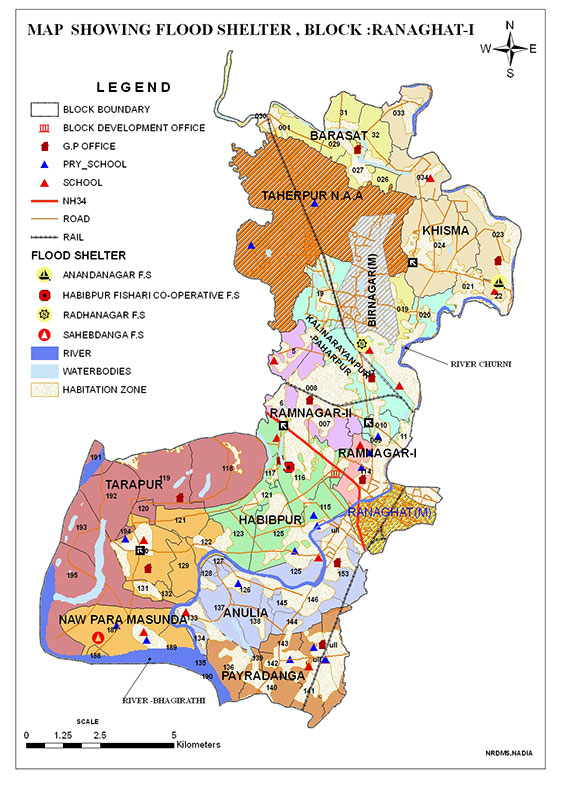
Click to enlarge.
Ranaghat I is a community development block that forms an administrative division in Ranaghat subdivision of Nadia district in the Indian state of West Bengal. Ranaghat police station serves this block. Headquarters of this block is at Habibpur. It is located 22 km from Krishnanagar, the district headquarters.
Ranaghat I CD Block has an area of 122.99 square km.
Gram panchayats of Ranaghat I block/ panchayat samiti are: Anulia, Habibpur, Barasat, Kalinarayanpur, Paharpur, Khisma, Nawpara Masunda, Payradanga, Ramnagar I, Ramnagar II and Tarapur.
As per 2011 Census of India Ranaghat I CD Block had a total population of 232,282, of which 120,847 were rural and 111,435 were urban. There were 119,444 (51%) males and 112,838 (49%) females. The population below 6 years of age was 21,717. Scheduled Castes numbered 84,911 and Scheduled Tribes numbered 4,438.
Parnership Model Block Shantipur
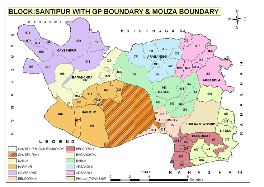
Click to enlarge.
Santipur is a community development block that forms an administrative division in Ranaghat subdivision of Nadia district in the Indian state of West Bengal. Shantipur police station serves this block. Headquarters of this block is at Fulia Kolony. It is located 21 km from Krishnanagar, the district headquarters.
Santipur community development block has an area of 178.98 square km.
Gram panchayats of Santipur block/ panchayat samiti are: Arbandi I, Arbandi II, Babla, Baganchra, Belgoria-I, Belgoria-Ii, Fulia Township, Gayeshpur, Haripur and Nabla.
As per 2011 Census of India Shantipur CD Block had a total population of 241,080, of which 154,256 were rural and 86,824 were urban. There were 124,400 (52%) males and 116,680 (48%) females. The population below 6 years was 24,576. Scheduled Castes numbered 99,539 and Scheduled Tribes numbered 3,189.