


Area of Implementation
Murshidabad District
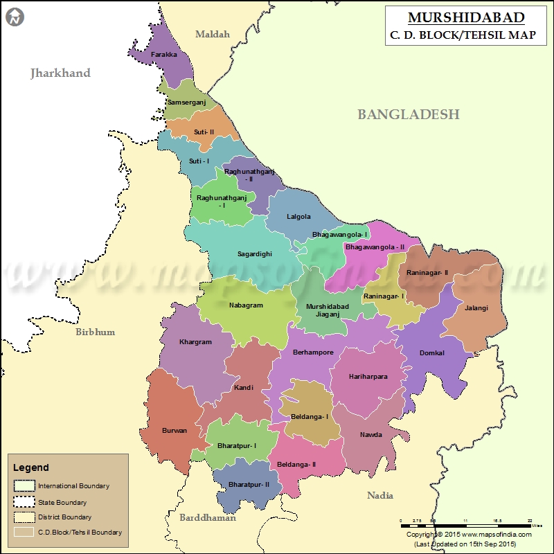
Click to enlarge.
Murshidabad, a district of West Bengal, in eastern India situated on the left bank of the river Ganges, is very fertile for agricultural activities. Covering an area of 5,341 km² with a population of 7,102,430 (according to 2011 census), it is a densely populated district and the ninth most populous in India out of a total 640.
Once, a seat of power of the Nawabs of Bangla the capital of Bengal was moved to the newly founded city of Calcutta aftera few years after Nawab Siraj-ud-Daula lost to the British at the Battle of Plassey. West Bengal’s Malda district to the north, Jharkhand’s Sahebganj district and Pakur district to the north-west, Birbhum to the west, Bardhaman to the south-west and Nadia district due south. The international border with Bangladesh Rajshahi Division is on the east.
The district comprises two distinct regions separated by the Bhagirathi River. To the west lies the Rarh, a high, undulating continuation of the Chota Nagpur plateau. The eastern portion, the Bagri, is a fertile, low-lying alluvial tract, part of the Ganges Delta.
The district is drained by the Bhagirathi and Jalangi rivers and their tributaries. Bhagirathi is a branch of the Ganges, and flows southwards from Farakka barrage where it originates from the Ganges. It flows southwards through the district and divides it into more or less equal halves.
Most of the land is arable, and used as agricultural land. Commonly seen trees are Neem, Mango, Jackfruit.
Jowbona is a popular village near nowda thana and also called green village in West Bangal.
Most of the people depend on agriculture for their livelihood. There are some silk farms and some weaving machines, but they are losing out fast against the modern industries. Murshidabad is famous for the high quality silk produced here.Beedi industry is also there. Many of the India’s major beedi companies are from this district.
Trade and business are conducted primarily with Asansol, Burdwan and Kolkata. There were some discussions between India and Bangladesh to open an internal water transport link between Dhulian and Rajshahi but it has not materialized yet.
In 2006 the Ministry of Panchayati Raj named Murshidabad one of the country’s 250 most backward districts out of a total of 640. It is one of the eleven districts in West Bengal currently receiving funds from the Backward Regions Grant Fund Programme (BRGF).
Partnership Model Block Nabagram
Nabagram is a community development block that forms an administrative division in Lalbag subdivision and is located 24 km from Baharampur, the district headquarters with an area of 305.61 square km.
Gram panchayats in Nabagram block/ panchayat samiti are: Amarkunda, Gurapashla, Hozbibidanga, Kiriteswari, Maharul, Nabagram, Narayanpur, Panchagram, Rasulpur and Shibpur.
As per 2011 Census of India Nabagram CD Block had a total population of 227,586, all of which were rural. Scheduled Castes numbered 56,622 and Scheduled Tribes numbered 16,770.
Partnership Model Block Domkal
Domkal is a community development block that forms an administrative division in Domkol subdivision of Murshidabad district. It is located 34 km from Baharampur, the district headquarters with an area of 304.27 square km.
Gram panchayats of Domkal block/ panchayat samiti are: Azimganjgola, Bhagirathpur, Dhulauri, Domkal, Garaimari, Ghoramara, Goribpur, Jitpur, Juginda, Juranpur, Madhurkul, Raipur and Sarangpur.
As per 2011 Census of India Domkal CD Block had a total population of 363,976, all of which were rural. Scheduled Castes numbered 9,515 and Scheduled Tribes numbered 1,219.
Partnership Model Block Hariharpara
Hariharpara is a community development block that forms an administrative division in Baharampur subdivision of Murshidabad district, located 19 km from Baharampur, the district headquarters with an area of 252.80 square km.
Gram panchayats of Hariharpara block/ panchayat samiti are: Beharia, Choa, Dharampur, Hariharpara, Humaipur, Khidirpur, Malopara, Raipur, Rukunpur, Swaruppur.
As per 2011 Census of India Hariharpara CD Block had a total population of 257,571, all of which were rural. Scheduled Castes numbered 16,403 and Scheduled Tribes numbered 3,040.